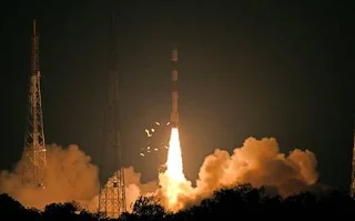
- Launching vehicle- Polar Satellite Launch Vehicle (PSLV-C46)
- Launching station- Satish Dhawan Space Centre (SDSC) SHAR, Sriharikota in Andhra Pradesh
About:
- RISAT-2B is a Radar imaging earth observation satellite which is indigenously developed by Indian Space Research Organisation (ISRO)
- The satellite is placed in an inclined orbit, 37 degrees to the equator to increase the number of imaging angles and opportunities and is being operated in X band
Features:
- Effective for whole day operation during day/night/all weather conditions
- Allows high-resolution spot imaging of any location of interest
- It is a Synthetic Aperture Radar (SAR): SAR is a form of Radar that creates 2-dimensional 0r 3-dimensional imaging of objects, for example, landscape.
- RISAT-2B provides RADAR imaging modes of 1m x 0.5m resolution and 0.5m x 0.3m resolution that are very high resolutions.
- It has vast ranging applications including agriculture, disaster management, geosciences, forestry, crops, hydrology, and Cryosphere
Background:
- RISAT-2B is India's 3rd radar imaging satellite program after RISAT-2 launched in 2009 (before RISAT-1) and RISAT-1 launched in 2012
- RISAT-2 is the first radar observation satellite India has launched in 2012 designed to monitor India's borders
- RISAT-1 was second in series and focused on natural resources management only
Question:
Q.1 RISAT-2B an earth observation satellite was developed by?
a) DRDO
b) European Space Agency
c) ISRO
d) NASA
Q.2 In the series of India’s RADAR imaging satellites, the first satellite launched was
a) RISAT-2B
b) RISAT-1B
c) RISAT-1
d) RISAT-2
a) DRDO
b) European Space Agency
c) ISRO
d) NASA
Q.2 In the series of India’s RADAR imaging satellites, the first satellite launched was
a) RISAT-2B
b) RISAT-1B
c) RISAT-1
d) RISAT-2


